"One and a half Lake Pontchartrains" – Hypoxic waters found east of the Mississippi
August 14, 2024
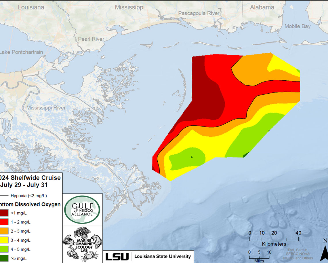
Researchers received funding to sample east of the mouth of the Mississippi River, where hypoxic waters were found.
BATON ROUGE - Waters east of the mouth of the Mississippi River are also falling prey to the Gulf of Mexico’s infamous Dead Zone, according to findings released by CC&E scientists in the wake of the annual hypoxia research cruise.
Professor Nancy Rabalais and Assistant Professor Cassandra Glaspie, along with Professor Emeritus R. Eugene Turner - all of the Department of Oceanography & Coastal Sciences, or DOCS - are co-lead scientists on the project, which measures the size of the hypoxic waters in the northern Gulf of Mexico.
The cruise normally samples off of the coasts of Texas and Louisiana. This year, additional funds allowed the team to document a stretch of low-oxygen waters spanning from the Chandeleur Islands south of New Orleans to at least as far as Mobile Bay. This is an area the size of one and a half Lake Pontchartrains, the team noted in the report of their findings.
Hypoxia occurs when excess nutrients contained in fresh water cause an algal bloom, which sinks to the bottom and then decomposes. This process consumes the dissolved oxygen in the water, meaning fish and other marine life near the bottom of the water column can no longer survive.
The actual extent of the eastern arm of the Dead Zone remains a question mark, said Rabalais, because the scientists were unable to continue sampling past Mobile. It is possible hypoxic waters can be found as far east as the Florida coast.
As it is, the presence of a significant hypoxic zone stretching from Louisiana to Alabama is not surprising. Rabalais said she headed research cruise to the east in 2011, and found low oxygen waters then. Other researchers and fishers have also reported hypoxia in the area.
The report put out by Rabalais and Glaspie’s team noted that the lower Mississippi and delta is a “leaky” system. This means freshwater run-off—including that from both the Mississippi and smaller watersheds like the Pearl River--may be directed to the east or west in the Gulf because of currents and wind, which helps explain the spread of hypoxia beyond a single defined area.
Additional funding for sampling in the eastern portion of the Gulf came from the Gulf of Mexico Alliance. The western cruise was funded by NOAA, National Centers for Coastal Ocean Science.
“Hypoxia news is shared among scientists and resource managers across the northern Gulf of Mexico,” Rabalais said. “It was good to have the additional funding for the mid-summer research cruise to work east of the Mississippi River.”
Findings in the Western Gulf
The western side of the hypoxic zone was found to be larger than predicted, coming in at 6,705 square miles. This makes it the 12th largest zone on record as it covers roughly an area the size of New Jersey, according to NOAA.
The annual sampling expedition provides metrics for the Dead Zone as part of the goal of reducing the average size of the dead zone to fewer than 1900 square miles by 2035. Currently the five-year average of the dead zone is 4298 square miles, more than two times larger than the 2035 target.