LSU-Led Team Researches the Impacts of Stalling Tropical Cyclones on the Gulf Coast and Atlantic Coastal Communities
October 14, 2024

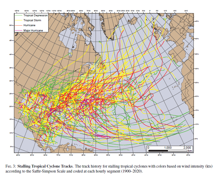
Figure 3: Stalling Tropical Cyclone Tracks. The track history for stalling tropical cyclones with colors based on wind intensity (kts) according to the Saffir-Simpson Scale and coded at each hourly segment (1900-2020).
© Copyright 06 September AMS
Photo Credit: AMS Journal of Applied Meteorology and Climatology
BATON ROUGE – Jill Trepanier, PhD, professor and chair of the Department of Geography & Anthropology in the LSU College of Humanities & Social Sciences, recently authored an article about stalling North Atlantic tropical cyclones in
the Journal of Applied Meteorology and Climatology. The work is a product of a joint effort between LSU and Texas A&M.
The article titled, “Stalling North Atlantic Tropical Cyclones,” discusses the impact
of stalling storms throughout the North Atlantic tropical cyclone season and how findings
will aid emergency mangers in affected regions by providing information that can be
used to better prepare for future storms.
“Stalling tropical cyclones are those that sit over one spot for a long period of time,” said Trepanier. The speed of a tropical cyclone includes rainfall accumulation,
storm surge, and exposure to high winds. When a storm stalls, these effects are even
greater. This slowing prolongs exposure to intense conditions and can increase total
damage. “Major concerns include continuous, unrelenting rainfall and inland flooding,”
she added. As of mid-2022, tropical cyclones or their remnants have produced the seven
costliest billion-dollar disasters in the United States.
The study found that stalls tend to occur in similar places over time and happen more
frequently later in the hurricane season, around October, when compared to the middle
of the season, in August. The risks from slow-moving storms are impacting growing
communities along the United States Gulf Coast, which is the fastest-growing coastal
region in the country, and Atlantic coastal zones. The population of these areas has
increased by 7.7 million since 2000 to 59.6 million in 2016.
“All landfalling hurricanes are dangerous in their own way. Fast-moving storms like
Beryl, Helene, and Milton carry their intensity and damage potential far inland, while
stalling storms compound the damage in a more concentrated location,” Dr. John Nielsen-Gammon,
Regents Professor at the Texas A&M Department of Atmospheric Science.

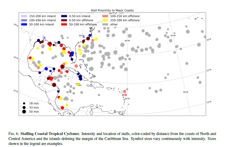
Figure 6: Stalling Coastal Tropical Cyclones. Intensity and location of stalls, color-coded by distance from the coasts of North and Central America and the islands defining the margin of the Caribbean Sea. Symbol sizes vary continuously with intensity. Sizes shown in the legend are examples.
© Copyright 06 September 2024 AMS
Photo Credit: AMS Journal of Applied Meteorology and Climatology
In addition, tropical cyclones are expected to produce more intense precipitation
due to the increased atmospheric water vapor as a response to climate warming and
stronger upward motion in storms. Storm tracks that recurve or loop over a region
can cause multiple landfalls and increase rainfall totals. The potential risk will
increase with continued sea-level rise, population migration, and increasing sea surface
temperatures in a warmer climate.
Tropical cyclones that stall reach Category 3+ strength (111 mph+) more frequently
than tropical cyclones that do not stall because they tend to have longer life cycles.
Trepanier and her team also suggest the number of stalls is increasing over time near
coastal zones, indicating a heightened risk for those within coastal communities.
If stalling storms become more frequent throughout the basin, the risk of devastating
conditions in areas impacted by tropical cyclones will increase. Trepanier and her
research team noted the importance of continued research to attempt to further explain
the discrepancies and geographic differences. Future research will focus on the mechanisms
for stalling storms, as well as the accumulated rainfall to better
understand the risk faced by coastal communities.
understand the risk faced by coastal communities.
About the LSU College of Humanities & Social Sciences
The LSU College of Humanities & Social Sciences positions students, faculty, and staff
to be visionary leaders in their respective fields, a tradition of excellence that
began with the college’s inception in 1908. For more news and information about the
LSU College of Humanities & Social Sciences, visit hss.lsu.edu.
Contact Sarah Gaar Keller
LSU College of Humanities & Social Sciences
Abbi Rocha Laymoun
LSU Media Relations